WALKING TRAILS ON CAYMAN BRAC
Traditional trails and other trails up and down the island including the only two remaining cross-island trails
See also Some nature hikes and special places on Cayman Brac in this blog
We have over 15 hikes on Cayman Brac, large and small, plus delightful walks along the beach. The beach and ironshore hikes have been omitted from this article, but two are spectacular: Long Beach past the end of the road at Spot Bay; and First Cay at the east end of the road on south side. For that matter the whole island can be walked along the beach (it’s been done) except for the eastern nose of the island. There, the cliff drops straight into the sea. In addition, if you’re willing to share space with cars, the whole island can be walked tip to tip along the roads (four hours).
Our hiking trails are our special feature. The other two islands have only a few traditional trails. Here, there were at least seven running right across the island, north (where the people lived) to south (past the traditional “grounds” to the windward side). Now only two remain –and we can save them. Remnants of the others are with us too. All of the trails honor those who built and maintained these lifelines, and they keep us in touch with our social and natural history.
The paths that have been lost have suffered the indignity of being converted from pedestrian to vehicular use. There’s not even a sidewalk! But there is the potential for the glory days to return. THE JOYS AND BENEFITS OF FOOT TRAVEL ARE BEING REDISCOVERED EVERYWHERE, FOR HEALTH, HISTORY, APPRECIATION OF NATURE AND A MORE CONTEMPLATIVE AND RESPECTFUL WAY OF LIFE.
Which trail is the most beautiful?
Which trail is most historic?
What is your favorite trail?
What is mine?
The names of our inland trails and walks are listed here. All were in walkable condition in early 2014, but all need work. Carry loppers!

Hiking trails on Cayman Brac
(most of the traditional trails and other hikes, listed from west to east)
| West End turtle crawl | aka Rabe’s trail |
| West End Community Park | an exercise path through the woods |
| Saltwater Pond Trail | one of only two remaining coast-to coast trails |
| Hayman’s Pond | to a geological phenomenon |
| Mass Grave | not a hike but our most important historic site |
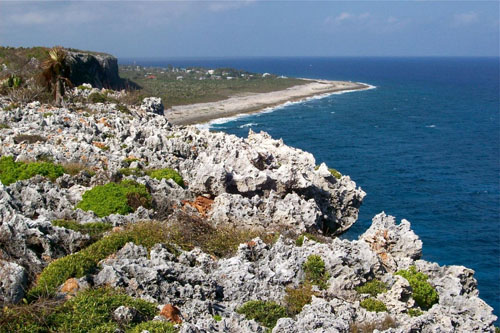
| The Splits | to a geological phenomenon |
| The Mountain | to a geological phenomenon |
| Stake Bay Bluff Road | lost to cars except for the cliff approaches |
| Deadman’s Bluff Road | shortened version; mostly given over to vehicles |
| Hemmington Road | from Skull Cave on the north, it goes half-way across |
| Bight Road | our iconic coast-to-coast traditional trail |
| Parrot Reserve Loop | a short trail on one side of The Bight Road south |
| Ann Tatum Road | sorry, cars only; name should come off this list perhaps |
| Charlotte’s Road | cars but for the cliff approaches, with a cave in each |
| Big Channel Bluff | cars except for spectacular northern approach |
| Lighthouse Trail | site of a future wilderness park, or just more houses? |

Besides preserving the two remaining north-to-south trails and the other trails, there are challenges. We have lost beach access on Cayman Brac. On Grand Cayman, public access paths have been designated and they will always allow Caymanians and visitors to get to the beach. On Cayman Brac this work has been promised but never done. In former days, people could follow the traditional trails right to water’s edge. The Bight Road is an example. Only 30 years ago, facing south, one could walk down with the assistance of a railing, then follow the path to the sea. All of that has been lost. Is there any place today where you can you gaze out to sea from the top of a cliff, then carry your picnic lunch down the cliffside path to the water’s edge and picnic under the sea grapes? You can do it at Charlotte’s Road (south) but the beach property could be sold tomorrow and an imposing wall built to block both view and passage. Lost, for a mess of pottage. Not long ago, volunteers walked and noted all the traditional beach access paths. If government would cooperate with a commission or a committee, they could be saved for all time. If not, we slip further towards “private property, no trespassing”. The beach belongs to us all by law, but what if we can’t get to it?

Pick a trail – walk one every day. And protect the terrain on both sides – a hiking trail would just be a town sidewalk if it weren’t for the forest on both sides. Rediscover an abandoned trail if you wish, and bring it back to use! Rock Road is one example. Enjoy our great outdoors!